
Translated material
The trace of the Torez
Where did the Malaysian Boeing come from: the study of Sergei Parkhomenko
On July 17, 2014, Boeing Malaysia Airlines was shot down in the sky above the Donetsk region. 298 people died. Eight months after the plane crash, it is still unknown what actually happened to the plane. According to one of the popular unofficial versions, the plane was shot down by Buk missile, released from the territory controlled by separatists. A photograph of an inversion trace, taken a few minutes after the crash of the liner, speaks in her favor. Journalist Sergei Parkhomenko conducted his own analysis of this picture, contacted his author and pointed to the place where the launch could be made.
Last Friday, I devoted a significant part of my program on Echo of Moscow Stories with the next documentary confirmations of the fact that the Boeing Malaysian, which followed the MH-17 flight, was shot down on July 17, 2014, the Earth-Athos, launched from the Buwo installation class. And this installation was in the territory controlled by separatists in the Donetsk region.
We are talking about photography taken by a resident of the city of Torez, not far from Donetsk, about 3-4 minutes after the launch of the rocket. The photographs captured an inversion trace of the rocket on the very early, starting section of its trajectory. This is the same “column of smoke”, the demonstrations of which for a whole year now noisily and hysterically harass various professionals and lovers to take the opponent by the throat. There are a lot of them: the workers of the information rear and fighters of the propaganda advanced mobilized for this war. And one of the particularly willingly used arguments in their simple campaign set is this one: “There is no trace in the sky - there are no missiles.”
For example, you remember how Mikhail Leontyev was sitting on this occasion on the air of the Echo of Moscow in November 2014: "... no one saw an inversion trace of starting the" Buk ". You can imagine, it costs a pillar of 10 minutes, a healthy pillar ... ”So it usually happens.
In fact, the desired “pillar”, of course, many saw. Let’s say, last week, Reuters published evidence of the inhabitants of the village of Krasny October (worm Zhovten) of the Donetsk region , over the heads of which a newly neglected rocket passed. These certificates were received by Reuters right on the spot: they were able to talk with local residents only now that the village was outside the zone of active hostilities.
Of course, there are also photographs of the launch. It was one of such filming that I spoke at Echo. But since the plot, which was entirely built on the analysis of the images, is to express on the radio, the lesson is quite strange in order not to say painful, I then promised to post on the network all the pictures that were described there. Let me do it now.
"The witness threw off the photo"
So, the basis of all this small investigation was photography, which, in reality, many have already seen, and which, in general, does not represent any special secret. Literally a few hours after the Boeing disaster, which flew over the Donbass and collapsed on the outskirts of the village of Grabov (traces of disaster can still be easily discerned on satellite shootings on Googlemaps), a photograph appeared on Twitter and gained quite widespread photography from the launch of the rocket. Probably many of those who read this will also remember her:
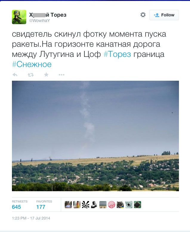
This tweet still hangs in its place, intact and preservation, only in the picture I smeared a part of a rather peculiar nickname of the author out of delicacy.
The picture was in hot pursuit subjected to “People’s Expertise”, so Syak was discussed and conveyed - and in the end was recognized as not worth attention, but most likely generally falsified. If desired, you can find many samples of such a homegrown examination, but in general, claims came down to several main points:
1) "There is some wrong weather." Say, the weather in the photo does not correspond to universally recognized ideas about what it was in the vicinity of Donetsk on the day of the disaster: here the sky is blue and clear, and on the video from the place of falling the plane - thick clouds;
2) "There are some spots and blots." Like, in the picture you can see some extraneous “artifacts”, which are very similar to traces of changes in Photoshop;
3) "There is nothing known there about who was filmed, where he was filming, why removed." Moreover, the author of the mentioned tweet is clearly not the author of the shooting and transfers it to the public “out of second hand”, referring to some “witness” who “threw off the photo”.
Having pronounced about the “next fake of the SBU”, the wide Internet masses about this episode safely forgot. And the belief that “no one saw a trace of the“ Buk ”completely prevailed. To talk about whether this universal skepticism had a natural origin, or in this episode information about dangerous and unpleasant photographs was discredited and buried by someone intentionally, I will not become now. Let us leave these thoughts to another case.
Meanwhile, the Torezskaya shooting (we will call it in the future) continued to attract the interest of investigators around the world and was subjected to more than a close professional expert analysis.
In mid -December of the past year, a large report on this shooting was shown by the Dutch television channel RTL: journalists attracted professional companies conducting the examination of photographs, interviewed specialists in military equipment, received certified satellite surveys of the areas of the earth's surface.
At the end of January 2015, the detailed-in two parts-the presentation of the results of their expertise was published by the network community of Bellingcat journalists. This community has now gained literally universal fame and enjoys exceptional authority. It became famous for the research and publications of materials on the civil war in Syria, as well as ISIS. A large article about this community and about its leader, a British journalist Elitte Higgins, published the New Yorker magazine in the fall of 2013. Recently, "Medusa" spoke in detail about Bellingcat.
Part one of the Bellingcat report is devoted precisely to the authenticity of the Torezsky shooting. Part two is focused in search of a specific place where the Buk installation launched a rocket that destroyed the Boeing MH-17. Both texts are available to everyone, so you can get acquainted with them even now.
So far, I just mention one of the conclusions that BellingCat experts came to, which marks one of the most common claims to the picture from that memorable tweet: the blue sky on the “Tozoza shooting” does not contradict anything at all.
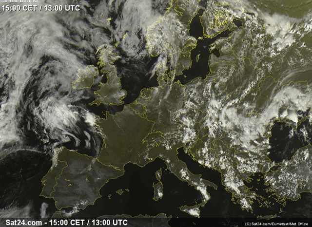
The place of the fall of the aircraft, where cloudiness was recorded, is defended from the point at which the photographer was placed by about 15 kilometers, and the zone at which the photographer’s lens was directed is another 20 kilometers. It is absolutely possible that at such a distance cloud cover over two points (launching a rocket and falling aircraft) could not be at all the same. Moreover, the satellite meteorological survey of this part of Eastern Ukraine shows: Donetsk and its suburbs were on the edge of the large cloud front that day, and the weather could be very changeable there.
Here, for example, is a frame from the SAT24.com website, which uses in its report in Bellingcat: it has a space from space, made 20 minutes before the MH-17 disaster, at 13-00 according to Greenwich July 17, 2014 (the moment of the aircraft falls is considered 16-20 local time, that is, 13-20 according to Greenwich, but only photos taken in the network are available in the network. "Round" hour):
But an enlarged fragment of the same photo. The red arrow marked the position of the city of Torez, in the vicinity of which events unfolded:
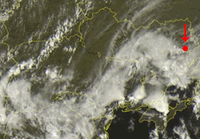
As you can see, the point of interest to us at the moment of interest was just in the “window” between the cloud masses. So the reproach in the "improper weather" should be considered insolvent.
In general, the Bellingcat examination is very scrupulous and convincing. I highly recommend that you familiarize yourself with both parts: there is a lot of useful things, which can come in handy, when analyzing a variety of shootings from all sorts of initially unreliable network sources. So do not regret the time.
However, I myself had a chance to do in detail the Torezsky shooting long before this expert publication. I plunged into the study of this story on my own, not knowing that at the same time other people carefully examine the same picture. It was all the more interesting to get acquainted with the Bellingcat examination, which really coincided with my conclusions.
Who shot?
Back in November, one colleague called me: he said that his friends from Donetsk were looking for my coordinates and want to connect me with the author of the very shooting. After some time, I “made friends” on Facebook with the man whose name was handed over to me and entered into a detailed correspondence with him. This man confirmed that last summer he lived in Torez and really took several photographs from the roof of his house, in which he believes, the launch of Buk is depicted on July 17.
“Photographer” (let's call it so for simplicity later) immediately sent me three huge files in NEF format with the original shoot. NEF is a specific RAW file format used by the Nikon camera manufacturer. Actually, this is what professionals call “digital negatives”: a “metadata”, that is, information about a specific camera, its settings, expositions, time of shooting and the like, are attached to a completely unprocessed source image, a fixed matrix. These three NEF files, about 16 megabytes each, are still stored for me.
I can’t put them in open access, but I will be ready to provide any investigator who will apply for them. In the meantime, I suggest everyone who wants to get acquainted with JPEG-AMI received directly from the NeF files. Their reduced copies:
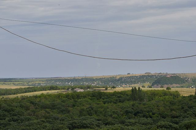
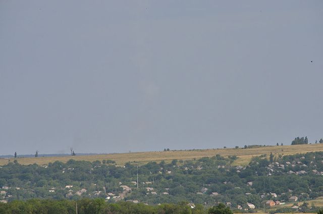
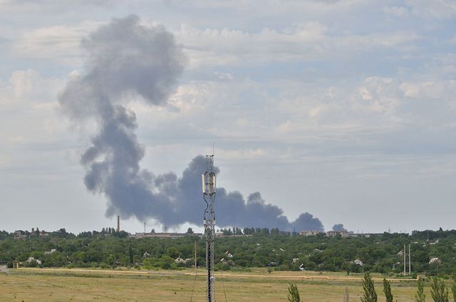
When examining these JPEG files (and even more so, the original NEF files in the RAW format) it becomes clear that there are no “divorces”, “blux” and other “artifacts”, which seemed to be such suspicious "network analysts", there are no on them. You can make sure for yourself. All this garbage turned out to be compressed by full -sized files to a tiny format necessary for pumping on Twitter. So the question of “claim number two” of the above mentioned can also be confidently considered closed.
In the famous July Twit, she appeared, as we see, photography No. 2, but in the original she is much brighter than the option that was then published. They “darkened” him before laying on Twitter, obviously, in order to make a more noticeable strip of smoke in the middle of the frame. Here I also “twisted” brightness and contrast - and deliberately did it sharply, deliberately, that the inversion trace, as well as puffs of smoke to the left of it (this is also a very important object, it was more convenient to see about it).
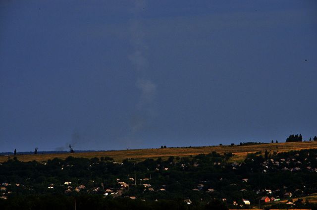
However, in the photograph in its original form, everything that interests us is clearly visible. So we will no longer use the darkened option.
About the circumstances of the shooting "photographer" told me the following:
- In the afternoon, being in his own apartment in the house on the outskirts of Torez, he heard a roar, much stronger than the already familiar sounds of working artillery, mortar gaps or salvos of Grad. He ran to the window and saw that the wind slowly smears a smoky trace over the horizon. The camera lay on the windowsill. He grabbed her and rushed down the stairs to the roof to remove from there. He snapped for the first time. I saw that the electric wires stretch right across the frame. I twisted the zoom to the maximum and took off the second time. Then he turned and saw from the other side, in the north (that is, just in the direction of Grabov) a pillar of dense black and blue smoke. I decided that the rocket hit some kind of gas station or a fuel oil tank. He climbed to the other side of the roof to remove the wires and antennas from where it does not interfere. For three minutes I climbed - then took the third picture. The fact that in the third picture the smoke from the just fallen aircraft did not know: I did not see any plane. Therefore, he did not shoot further: if he knew that he had fallen into the frame for the event, he would have shot, of course, more. But I learned about what exactly happened after a couple of hours. Then he sent shots to a friend, and he posted on Twitter.
A few days after our acquaintance, one of my colleagues-television officer, to whom I gave the coordinates of my new acquaintance, went to visit the “photographer”. He repeated the whole story with all the details in front of the camera. True, he asked to darken his face and change his voice on the record of the timbre. Nevertheless, there is a video version of this certificate at our disposal.
In the system information contained in the NEF files sent to me, there really was all the necessary information about the camera used, its settings and expositions, as well as the time of shooting these personnel:
"Photo 1" - 07/17/2014 16: 25: 41.50
"Photo 2" - 07/17/2014 16: 25: 48.30
"Photo 3" - 07/17/2014 16: 30: 06.50
This is, respectively, six and ten minutes after time, which is considered the moment of the death of the Boeing MH-17. The first two frames were removed, in fact, with a difference of a few seconds, and the third - about 4 minutes later. Converges.
Note, by the way, returning to the question of the weather that in photo 1 and photo 3, cloudiness is clearly visible. The sky looks cloudless only directly above the launch site of the rocket - in the frame made with the maximum increase.
And another very important commentary on the “photographer”: he explained that a column of smoke was quickly bent into the arc and demolished the wind to the right. At the same time, a large cloud of black smoke rose and gradually “smeared” him and gradually “smeared” him and gradually “smeared”, according to his assumption, formed just at the place of launch of the rocket. This cloud is clearly visible in the "darkened" photography. But it is not difficult to discern her on the original image.
Where did you shoot?
Then the most interesting begins. Of course, as soon as you start considering the Time Carriage, there is a strong temptation to try to more or less accurately establish where exactly the rocket was launched. “Photographer” in the conversation pointed to a specific place where he was shooting. And the first step was to check his words.
Already with a cursory glance at the first two frames, it becomes clear that there are enough details on them to reliably tie the shooting point to the real area. So the first thing was to mark two photos, determining their most characteristic details. Which I did.
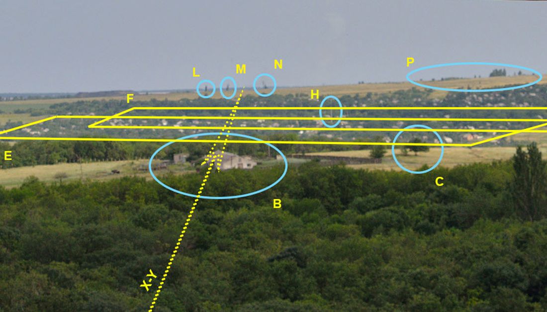
In photo 1, representing a wider angle of view (“general plan”, as professionals would say), many of these details are easily distinguished:
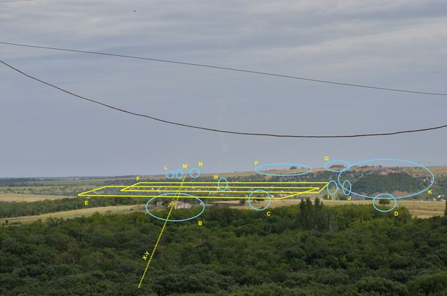
Here are some of the elements that are clearly distinguishable in the landscape:
B. Farm in the middle of the field;
C., D. Separate large trees;
E. Daching village in the foreground;
F. Another summer cottage village a little further;
H., I., J. The masts of low -voltage power transmission;
K. Old Minute Terricon, overgrown with trees and shrubs;
L., M., N. Large supports of the high -voltage line;
P. A group of tall trees in the distance;
Q. The roof of some industrial building.
In photo 2, which is a larger plan, some of the landmarks marked in the first photo, and here they can be seen even more clearly:
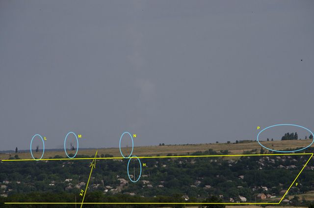
In particular, these are such:
F. The same “distant” country village, as in the first photo;
H. The highest of the masts of low -voltage power transmission from the first photo;
L., M., N. The same large supports of high -voltage transmission that are in the first photo. By the way, upon closer examination, it becomes clear that the commentator of that long -standing tweet was mistaken: this is not a “cable car between Lutugin and TSO”, namely the supports of the power transmission line;
P. Easily identified tall trees from the first photo.
The next step in the analysis is an attempt to identify these characteristic details on the “form from above”, that is, on the staff of satellite shooting. Fortunately, there are quite a lot of such personnel at our disposal, and they are made in a very good, detailed resolution. It is most convenient to look at them not in the usual Google Maps, but in the public Google Earth program.
Here is a fragment of satellite shooting that interests us, on which all the guidelines marked in two photographs are perfectly visible:
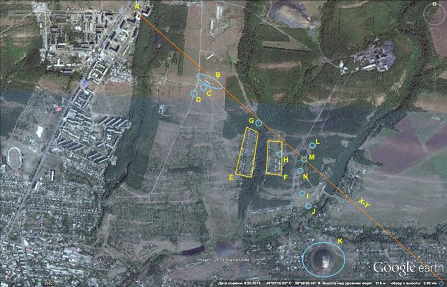
Point A here marked the initial position of the “photographer”, indicated by himself. Indeed, on satellite shooting, we find everything that fell into the lens: a farm, individual trees, two cottage villages, lines of low and high power drives, well -identified terricon (all landmarks are indicated here in the same letters as in the original photographs). So, the “photographer” did not lie to us, indicating his location.
But if so, then we have the opportunity to draw an imaginary “vision of vision”, according to which the “photographer” was visible black smoke, rising above the alleged starting point and gradually demolished by the wind to the right. In the photographs, we see it approximately in the direction of the average support of the high -voltage power transmission line - the one that is designated by our letter M. We can draw this line (XY) on the satellite map: from the point of shooting through a high electric mast. For comparison, I also noted it in photographs with marked landmarks. There is a rather serious chance to find on this axis or very close to it, from where the rocket was launched.
What did you shoot?
Now you can look at satellite shooting on a smaller scale and trace where this axis leads, and which objects are found directly on it or nearby.
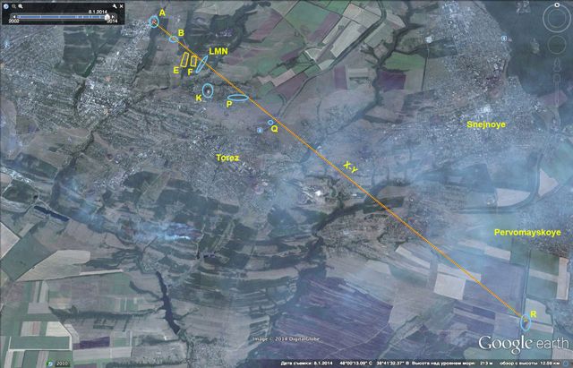
I give everyone to independently draw the same line in the satellite photograph of this area of Eastern Ukraine and with their own eyes to consider all the deserves there.
I myself allow myself to indicate one site, which personally seems very worthy of attention to me:
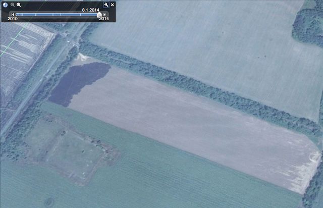
Вот это вытянутое поле возле дороги выглядит крайне интересно. У левого края его — хорошо заметные следы от маневров какой-то тяжелой техники. И рядом — большой кусок обгорелой, черной земли, частично уже запаханный. Отметим также, насколько удобной была бы такая позиция для размещения ракетной установки: прямо с дороги имеется съезд через неширокую, но густую лесополосу, которая скрывает поле от посторонних глаз. И еще одна деталь: дорога эта ведет не куда-нибудь, а именно в поселок Снежное, где в июле 2014 года была многократно сфотографирована и снята на видео установка «Бук». Вот, например, один из широко распространившихся в Сети видеофрагментов. В аннотации к нему на Youtube можно найти множество ссылок на точное место съемки в Google Maps:
Еще более интересный материал для размышлений предоставляют архивы Google Earth, где можно найти более ранние спутниковые фотографии той же точки. Приведенная выше фотография сделана через две недели после роковой даты: 1 августа 2014 года (дата съемки видна слева вверху). Пятно обгорелой земли уже есть, и поле кажется нетронутым.
А вот так выглядела та же точка за год до трагедии с рейсом MH-17, а именно 8 августа 2013 года:
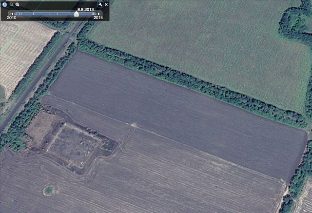
Поле на своем месте, но никакой обугленной кляксы в углу рядом со съездом с дороги на нем не видать.
Ну и наконец, самая поздняя из имеющихся картинок датирована 15 августа 2014 года, ровно через месяц после предполагаемого запуска.
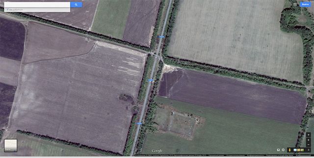
Пятно и следы техники на месте, но поле уже начали запахивать. Именно в таком виде этот объект и по сей день можно сколько угодно разглядывать даже на простых Google Maps.
А теперь самое время сказать, что и расследователи из Bellingcat, и журналисты голландского телеканала RTL, пройдя практически такую же цепочку размышлений и манипуляций с разметками на картах и фотографиях, указали не на ту площадку, которая показалась наиболее «подозрительной» мне, а на другую. Впрочем то поле, которое они считают местом запуска ракеты, отстоит от той точки, на который указали мы, всего на 300 метров: это кусок вспаханной земли в левом верхнем углу поля, которое хорошо видно тут же, на последней приведенной нами картинке, но только не справа, а слева от дороги.
Неплохая «кучность» результатов, правда? Оттолкнувшись от одной и той же фотографии с дымным следом, проанализировав ее независимо друг от друга и сориентировавшись на карте по одной и той же логике, мы пришли к двум подозрительным точкам на дистанции в несколько десятков километров от места съемки, отстоящим одна от другой меньше чем на полкилометра. По-моему, этот результат кое-чего стоит.
Но все-таки: кто из нас прав? Где стояла пусковая установка? Где искать следы? Слева от той дороги или справа? Несомненно, и там и там.
Ведь на самом деле весь смысл этого кабинетного расследования заключается в том, чтобы указать на место, где следует уже не картинки разглядывать, а лопатой рыть. Совершенно очевидно, что современные технологии позволяют обнаружить следы такого характерного вещества как ракетное топливо даже и через год после того, как оно могло появиться в той или иной точке. И никакие попытки что-нибудь спрятать или замаскировать тут не помогут. Можно хоть на три метра срыть землю на «подозрительных» полях, можно ее чем угодно засыпать и как угодно перепахивать, но частицы горючего все равно сохранятся и в почве, и в остатках прошлогодней растительности, и на стволах и ветвях деревьев неподалеку.
Осталось выяснить несколько несложных мелочей: брали ли уже с этих точек образцы почвы на анализ? Если да — то где результаты этих анализов? Если нет — то почему? Требовали ли этого участники международной следственной группы? Какие ответы получили? Могут ли они сделать это теперь, когда район Червоного Жовтня и Снежного наконец оказался относительно удален от линии фронта?
Впрочем, о следствии в этом деле вообще надо бы сказать еще несколько слов.
Для кого снимал?
Через несколько дней после публикации той фотографии в Твиттере «Фотограф» понял, что оставаться в Торезе ему небезопасно. Слишком просто было его вычислить: в конце концов, в маленьком шахтерском городке найдется не так много людей, которые фотографируют такой высококлассной, дорогой камерой. И автора можно было определить просто по качеству снимков. Вскоре после этого ему удалось переехать в такой же небольшой городок, но оставшийся по другую сторону линии фронта, на территории, контролируемой Украиной.
Оттуда через знакомых в Киев было отправлено сообщение об имеющейся ценной съемке. Не прошло и нескольких недель, как к «Фотографу» явилась представительная делегация следователей: там были и украинские, и голландские, и австралийские участники следственной группы. «Фотограф» был подробно допрошен. С него взяли детальные объяснения относительно места, времени, характера съемки, удаленности сфотографированного объекта, предполагаемой точки, откуда мог подниматься дымный след. Наконец, «Фотографа» попросили уступить следователям ту самую камеру, которой была сделана съемка (взамен привезли и вручили другую, еще лучше прежней, рассказал он мне потом).
Таким образом мы можем не сомневаться, что у следствия, в том числе у международной его части, есть вся необходимая информация об этой съемке. Но следствие по этому поводу аккуратно и сосредоточенно молчит.
Why - I don't know. Наверное, это самый важный вопрос во всей истории с этими съемками. И именно на него у меня нет совсем никакого ответа.
Однако мне кажется, что сейчас в эпопее расследования катастрофы «Боинга» MH-17 кое-что начинает шевелиться и ворочаться. Такое впечатление, что дело медленно двинулось вперед, к развязке. Вышли в эфир со своим сюжетом голландцы на RTL, опубликовали свою экспертизу британцы из Bellingcat, другие голландцы — с телеканала NOS — опубликовали подробный текст о сложностях расследования, группа из Reuters доехала до Красного Октября. Ну, вот теперь и мы рассказали все, что знали.
Может быть, следователям пора решаться на финальное усилие? Оно самое трудное, конечно. Но рано или поздно его ведь все равно придется совершить?