
Translated material
Two earthquakes up to 6 points occurred on the Indonesian island of Sumatra
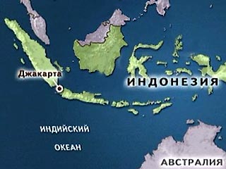
Underground shocks by force up to 6.0 points on the Richter scale were registered on Tuesday night on the Indonesian island of Sumatra with an epicenter of 200 km northeast of the Padang port city, the administrative center of the West Sumatra province (1.5 thousand km west of Jakarta).
After about 7 hours, an earthquake with a capacity of 5.0 points occurred in the Mentai Strait of 165 km southwest of Padang. There were no reports of victims and destruction at this hour.
In Padang, located on the coast of the Indian Ocean, thousands of residents in panic left the houses, fearing a repetition of the tragedy on December 26, 2004, ITAR-TASS reports.
In the western part of Sumatra, in the area of the cities of Padang and Benguluk, powerful earthquakes regularly occur. The previous time, underground shocks with a force of 7.3 points shook this mountain district on July 26 last year, and two years earlier, as a result of a 7-point earthquake, more than 100 people died there. Earthquakes of 1994,1996 and 2000 were led to even more victims in Sumatra.
The island of Sumatra, like the entire Indonesian (Malay) archipelago, is located at the junction of the Indo-Australian and Euro-Asian tectonic systems and is part of the so-called The Pacific “Fire Ring” is a chain of seismically active zones and volcanoes, including underwater, stretching from the coast of Mexico south to New Zealand.
Therefore, tectonic cataclysms occur in Indonesia - "country of 18 thousand islands" - quite often - on average 4-5 times a day.