
Translated material
They look eagerly on the road
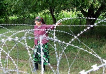
Georgia accused Russia of capturing land on the border between the territory controlled by Tbilisi, and unrecognized southern Ossetia. It is reported by RTVI. On July 10, the Georgian Ministry of Internal Affairs, the Russian military, located in South Ossetia, moved the dividing line to the south, deep into the border villages. It is emphasized that now Russian invaders have strengthened one and a half kilometers from the country's main highway.
Tbilisi regarded the actions of Russia as a provocation and violation of international law.
Meanwhile, the Russian authorities and the regime in Tskhinvali call the arrangement of the "borders of South Ossetia", the television channel reports.
On Tuesday, the Russian Foreign Ministry published a report on the telephone conversation of the deputy head of the department Grigory Karasin with the First Deputy Minister of Foreign Minister of Georgia David Dondua. During the conversation, Dondua expressed dissatisfaction with the transfer of border signs deep into the Georgian territory. “In response, it was said that these claims are not addressed,” the Russian Foreign Ministry reports. “Any problems related to the passage of the line of the border should be discussed with the South Ossetian side.”
"Karasin further described the propaganda hype raised in Georgia as far -fetched," the report also says. According to the Russian official, the border sign was set exactly in the place where he stood until April 8, "when he was dismantled during the provocative television show of the Georgian television channel" Imady ".
“It is time to decide the Georgian side: does it intend to follow the positive logic of the healing of relations with Russia or will he continue to resort to provocative inventions, which each time discard the process of bilateral normalization back,” the Smolensk Square emphasized.
Earlier, Georgia repeatedly accused Russia of seizing territories by moving the illegal border with South Ossetia. In November 2013, the Financial Times wrote that the Russian military use the cards of 1921 of the publication and, guided by them, move the border to the south, cutting the hectares of the Earth.